Archive for the ‘AstroInfo Article’ Category
 Partial Solar Eclipse Viewing 2012 – Solstice Park
Did you know there’s going to be a partial solar eclipse visible from Seattle in just over a week? Come to Solstice Park and share the experience. NEVER, EVER, EVER look directly at the Sun. Even when it is partially eclipsed. You risk damaging your eyes. To find safe ways to observe please visit this website. Sunglasses are not enough. Build a pinhole projector instead.
- When: Sunday May 20, 2012 at 5:01pm-7:25pm (maximum eclipse is at 6:17pm)
- Where: Solstice Park – all the way up the hill from the tennis courts (or, if you’re not in Seattle, wherever you have a view of the Sun! Go to this website to find the times for your location.)
- Who: Everyone welcome, as usual.
This is a partial annular solar eclipse. This is the first solar eclipse visible from Seattle in ten years.
Unfortunately, I will not be in attendance this time, but I will be around for the June 5 Transit of Venus. I am simply facilitating this gathering from afar for the solar eclipse. I’m hoping to find an astronomy friend to show up and talk about safe solar viewing (anyone?).
If you’re interested – here’s the timing of various celestial events on Saturday from Seattle, courtesy of the U.S. Naval Observatory Astronomical Applications Department:
Sun and Moon Data for One Day
The following information is provided for Seattle, King County, Washington (longitude W122.3, latitude N47.6):
Sunday
20 May 2012 Pacific Daylight TimeSUN
Begin civil twilight 4:48 a.m.
Sunrise 5:25 a.m.
Sun transit 1:06 p.m.
Sunset 8:47 p.m.
End civil twilight 9:25 p.m.MOON
Moonset 7:54 p.m. on preceding day
Moonrise 5:11 a.m.
Moon transit 12:58 p.m.
Moonset 8:52 p.m.
Moonrise 5:50 a.m. on following day
This event is my part of the NASA’s Solar System Ambassador program, and thanks to West Seattle Blog for publicizing the last few!
Everyone is welcome!
![]()
~ A l i c e !
 Spring Equinox Sunset Watch 2012
It’s time for the 12th seasonal sunset watch (We’re at 3 years of these, folks)!!
- When: March 19, 2012 at 7:05pm (so come at 6:45pm)
- Actual sunset is supposed to be at 7:22, but at the summer solstice we noticed that the Sun set about 10 minutes earlier than the USNO says it does, so I’ve moved the time of our sunset watch up so we don’t miss it. I added another 5 minutes for the tall trees of Lincoln Park blocking our view. In Autumn the timing seemed to line up correctly – what will it do this time?
- Where: Solstice Park – all the way up the hill from the tennis courts (or, if you’re not in Seattle, wherever you have a view of the western horizon!)
- Who: Everyone welcome, as usual.
Come watch the spring equinox sunset at Solstice Park in West Seattle on Monday the 19th. We’ll see if the sunset lines up with the placed marker (it did for summer, but we weren’t sure in autumn or winter). I’ll be there even if it is cloudy because sometimes the Sun peeks through just as it begins to set, but if it is driving rain or sleet I’m staying home with some hot tea!
If you’re interested – here’s the timing of various celestial events on Saturday from Seattle, courtesy of the U.S. Naval Observatory Astronomical Applications Department:
Sun and Moon Data for One Day
The following information is provided for Seattle, King County, Washington (longitude W122.3, latitude N47.6):
Monday 19 March 2012 Pacific Daylight Time
SUN
Begin civil twilight 6:42 a.m.
Sunrise 7:13 a.m.
Sun transit 1:17 p.m.
Sunset 7:22 p.m.
End civil twilight 7:52 p.m.MOON
Moonset 3:40 p.m. on preceding day
Moonrise 5:38 a.m.
Moon transit 11:08 a.m.
Moonset 4:47 p.m.
Moonrise 6:02 a.m. on following dayPhase of the Moon on 19 March: waning crescent with 8% of the Moon’s visible disk illuminated.
New Moon on 22 March 2012 at 7:38 a.m. Pacific Daylight Time.
This event is my part of the NASA’s Solar System Ambassador program, and thanks to West Seattle Blog for publicizing the last few!
Everyone is welcome, see you there!
![]()
~ A l i c e !
 The Eddy and the Plankton
I have to share. NASA released a couple of somewhat mind-blowing photos earlier this month. This is a 150-km-wide vortex off the coast of South Africa. You can see it because it is full of plankton.
The Eddy
There are currents in the ocean that are as big as the ocean itself (look up the North Pacific Gyre if you don’t believe me), so I shouldn’t be surprised to see a little whirlpool that’s a bit larger than Connecticut. It’s also the size of the Puget Sound area – defined as Olympia to Bellingham, Seattle to Snoqualmie Pass.
But, it looks like something out of science fiction.
The Satellite
This image is from NASA’s Terra satellite, and is a natural-color image (in case you were wondering). You have probably seen images from Terra that were put together using the same “near-real-time” technology before–many of the satellite images of wildfires are from Terra or another of NASA’s Earth Observing System satellites.
The Plankton
Eddies like this one can stir up the ocean, bringing warmer water into colder places, and kicking up nutrients from deeper in the sea. Like yeast, when you provide the right environment you’ll get a “bloom” happening. As you know if you’ve ever tried to make bread, the key is warm, well-fed organisms. A bloom is a visible increase in the amount of microscopic stuff in water. In the case of yeast the bloom is from byproducts of the process of living (i.e. yeast “poop”), but for plankton, this bloom is more likely reproduction – millions of new “baby” plankton.
Want More?
![]()
~ A l i c e !
 Winter Solstice Sunset Watch 2011
In light of the Lunar Eclipse this past weekend, it’s time for the 11th seasonal sunset watch!!
- When: December 21, 2011 at 4:05pm (so come at 3:30pm)
- Actual sunset is supposed to be at 4:20, but at the summer solstice we noticed that the Sun set about 10 minutes earlier than the USNO says it does, so I’ve moved the time of our sunset watch up so we don’t miss it. I added another 5 minutes for the tall trees of Lincoln Park blocking our view. In Autumn the timing seemed to line up correctly – what will it do this time?
- Where: Solstice Park – all the way up the hill from the tennis courts (or, if you’re not in Seattle, wherever you have a view of the western horizon!)
- Who: Everyone welcome, as usual.
Come watch the winter solstice sunset at Solstice Park in West Seattle on Wednesday the 21st. We’ll see if the sunset lines up with the placed marker (it did for summer, but will it for winter?). I’ll be there even if it is cloudy because sometimes the Sun peeks through just as it begins to set, but if it is driving rain or sleet I’m staying home with some hot tea!
If you’re interested – here’s the timing of various celestial events on Saturday from Seattle, courtesy of the U.S. Naval Observatory Astronomical Applications Department:
Sun and Moon Data for One Day
The following information is provided for Seattle, King County, Washington (longitude W122.3, latitude N47.6):
Wednesday 21 December 2011 Pacific Standard Time
SUN
Begin civil twilight 7:19 a.m.
Sunrise 7:55 a.m.
Sun transit 12:07 p.m.
Sunset 4:20 p.m.
End civil twilight 4:56 p.m.MOON
Moonset 1:07 p.m. on preceding day
Moonrise 4:30 a.m.
Moon transit 9:11 a.m.
Moonset 1:47 p.m.
Moonrise 5:45 a.m. on following dayPhase of the Moon on 21 December: waning crescent with 11% of the Moon’s visible disk illuminated.
This event is my part of the NASA’s Solar System Ambassador program, and thanks to West Seattle Blog for publicizing the last few!
Everyone is welcome, see you there!
![]()
~ A l i c e !
 Worlds of Stone: 11/23/2011
As part of the current show (Worlds of Stone) at Pacific Science Center we’re updating the images we show from NASA’s MESSENGER and Dawn missions on a weekly basis. I’ll try to show them to you the week after we use the in the planetarium.
Dawn
NASA Caption
Date acquired: November 8, 2011
Release Date: November 22, 2011
This Dawn image shows a young, fresh crater, which is about 7 km in diameter, in the lower right part of the image. This crater has both dark and bright rays fanning out from it. The bright rays extend much farther from the crater than the dark rays, which are located close to the crater rim. Rays around a crater are formed when relatively small sized pieces of material are ejected by the impact that formed the crater. When larger pieces of material are ejected they can form secondary craters. Clusters and chains of sub-kilometer diameter secondary craters occur roughly 15 km to 20 km away from the rim of the 7 km crater. They are called secondary craters because the blocks that formed them were ejected from a crater formed by a primary impact. Sometimes blocks fall back into the initial crater. Many of these blocks can be seen on the floor and walls of the 7 km diameter crater. These blocks are several tens of meters in size.
Image Credit: NASA/ JPL-Caltech/ UCLA/ MPS/ DLR/ IDA
Alice Says:
Pretty good description of crater rays and why this is cool by NASA. Why is it cool? Because it has dark AND light rays. Looks pretty neat to me.
Vocabulary from above: “sub-kilometer diameter” – craters that are less than a kilometer across.
Interpretation notes: “Why do you think there are two colors of rays?” “Were the rays made by the same impact or two events?” “Why do you think that” Which craters in this picture happened before or after the main crater on the right?”
MESSENGER
Released November 22, 2011
Date acquired: October 28, 2011
Of Interest: This image, taken with the Narrow Angle Camera (NAC), shows a pair of secondary crater chains. These features are formed when ejecta from a primary impact is thrown outward from the growing crater cavity. As chunks of ejecta fall back to the surface, they can form chains of secondary craters that often overlap.
Credit: NASA/Johns Hopkins University Applied Physics Laboratory/Carnegie Institution of Washington
Alice Says:
Just like in the Dawn image above, we’re talking about “secondary craters” – craters formed by stuff tossed up by an impact. This is, believe it or not a crater chain, but the impacts are so close together it makes what looks like a single gouge.
Interpretation notes: “What do you think this is?” “How do you think this shape could have been made?” “What do you think did this?” “What about this picture is interesting to you?”
Want More?
Worlds of Stone at Pacific Science Center
![]()
~ A l i c e !
 Worlds of Stone: 11/08/2011
As part of the current show (Worlds of Stone) at Pacific Science Center we’re updating the images we show from NASA’s MESSENGER and Dawn missions on a weekly basis. I’ll try to show them to you the week after we use the in the planetarium.
Dawn
NASA Caption
Released November 7, 2011
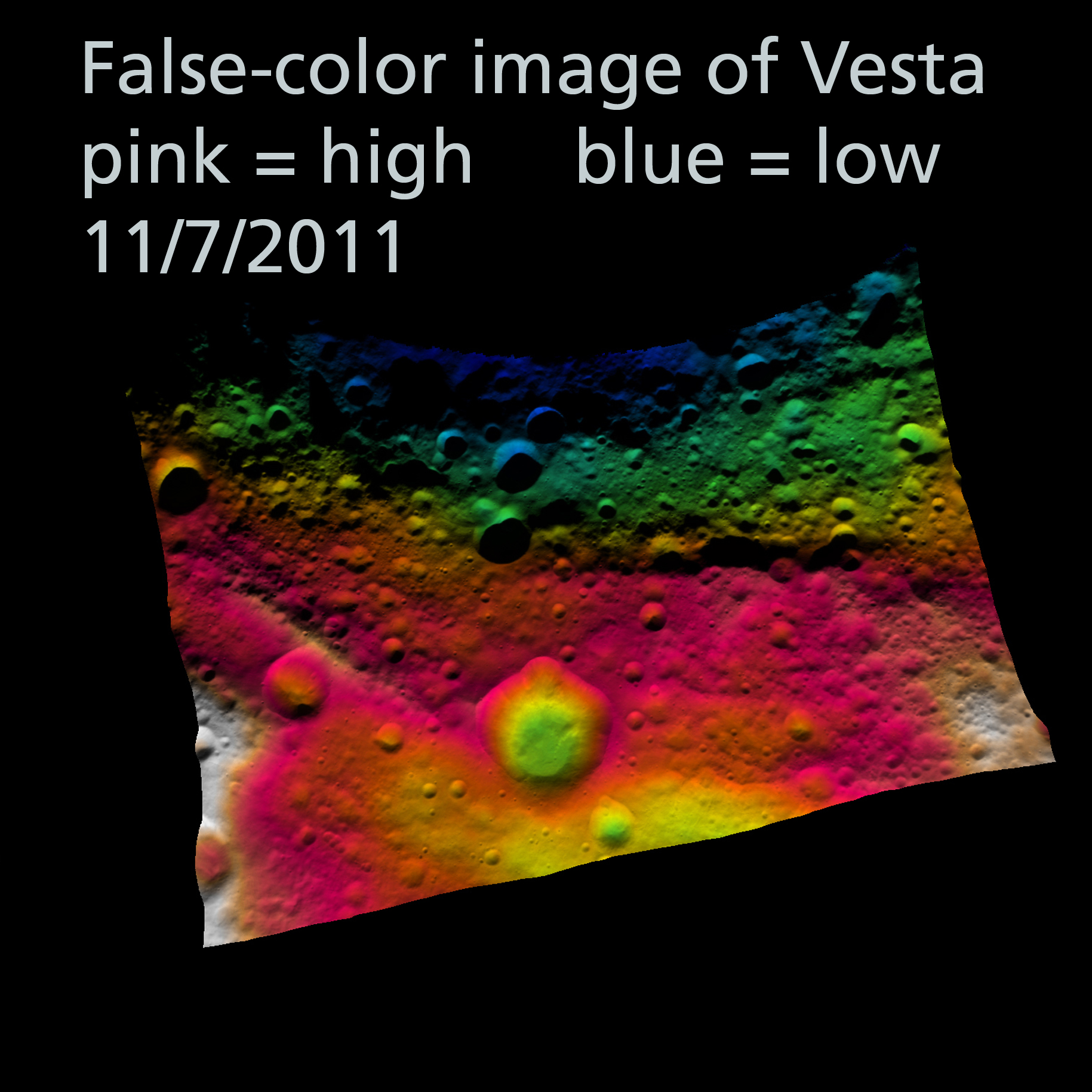
PASADENA, Calif. — These Dawn FC (framing camera) images show part of Vesta’s equatorial region, which contains a prominent, deep impact crater (lower center of image) and large troughs (linear depressions). The various colors correspond to the height of the area that they color. For example, the white areas in the bottom corners of the image are the highest areas and the blue areas along the top of the image are the lowest. The prominent impact crater is set into a topographically high area defined by the red and white color-coding. Above this area there are a number of deep troughs represented by green and blue color-coding. A conspicuous trough on the left, which looks like it could be quite deep in the albedo image, is shown by the color-coding in the topography image to be only a little shallower than the area surrounding it.
Image Credit: NASA/ JPL-Caltech/ UCLA/ MPS/ DLR/ IDA
Alice Says:
This is a standard terrain image with rainbow colors corresponding to elevation. Pink and white are high elevations, blue and green are low. There’s a weirdness in this one though – the colors go in this order: blue, green, yellow, orange, pink, brown, white. Orange and brown look almost the same.
My favorite feature here is the line running up to the left from the big crater in the middle. Due to the weirdness with the scale, I can’t tell if this is a ridge or a valley. What do you think? I have an e-mail out to JPL.
MESSENGER
Released November 8, 2011
Date acquired: October 31, 2011
Of Interest: This eastward-looking image shows a wider view of the beautiful unnamed crater highlighted in yesterday’s featured image (center). The complicated folds and fractures that deform the once smooth floor of the Caloris basin can also be seen.
This image was acquired as a high-resolution targeted observation. Targeted observations are images of a small area on Mercury’s surface at resolutions much higher than the base maps. It is not possible to cover all of Mercury’s surface at this high resolution during MESSENGER’s one-year mission, but several areas of high scientific interest are generally imaged in this mode each week.
Credit: NASA/Johns Hopkins University Applied Physics Laboratory/Carnegie Institution of Washington
Alice Says:
If this image doesn’t take your breath away I can’t help you. Those craters look like raindrops in a puddle to me. This picture is so beautiful. Mercury looks like a PLANET here, not just a desolate collection of black-and-white photos. Of note: the bright areas are not highlights, they are crater rays – new dirt (“regolith”) kicked up by recent impacts.
Want More?
Worlds of Stone at Pacific Science Center
![]()
~ A l i c e !
 Worlds of Stone: 10/25/2011
As part of the current show (Worlds of Stone) at Pacific Science Center we’re updating the images we show from NASA’s MESSENGER and Dawn missions on a weekly basis. I’ll try to show them to you the week after we use the in the planetarium.
Dawn
NASA Caption
Released October 25, 2011
Date acquired: August 11th 2011
Instrument: Dawn FC (framing camera)
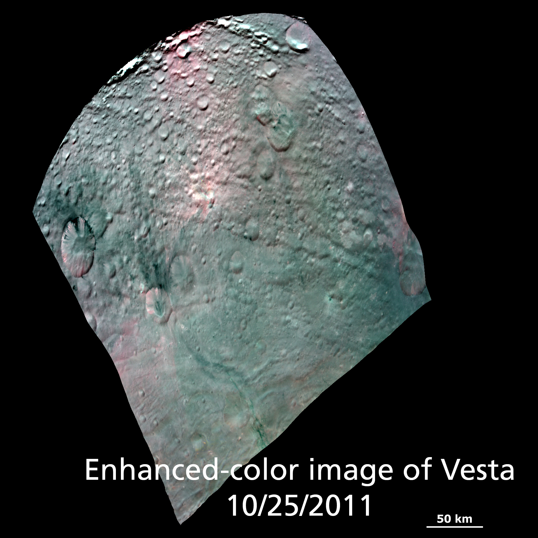
PASADENA, Calif. — This Dawn FC (framing camera) composite images show the spectacular spectral diversity of Vesta’s surface. This image shows a Red-Green-Blue color composite image of Vesta. The images from these 3 filters were combined into this one RGB composite image, which enhances Vesta’s coloration..
Image Credit: NASA/ JPL-Caltech/ UCLA/ MPS/ DLR/ IDA
Alice Says:
In short, this is a false-color image. I’ve chosen one of the two that was originally part of this release. I chose this one because it is what I would call “less false” color. Instead of an image with crazy colors depicting specific minerals, I thought it would be interesting to look at a picture that gives us a bit of a sense of what color Vesta might be rather that the greyscale images we’ve been seeing so far.
MESSENGER
Released October 23, 2011
Date acquired: October 10, 2011
Instrument: Narrow Angle Camera (NAC) of the Mercury Dual Imaging System (MDIS)
Of Interest: The large crater here was formed by a very low angle, or oblique, impact. Although impacts at most angles produce circular craters, impacts with incidence angles <15º (from the horizontal) will create elliptical craters. This crater is superposed on an older, circular crater.
Alice Says:
NASA’s explanation is good. I picked this image because it’s a great way to engage with the geology of Mercury.
Here’s a teachable moment: ask guests why the crater might have such a strange shape.
And what about that ridge in the middle? Often when you have a peak in the middle of a crater it’s a “splashback” – like those in slow-motion images of milkdrops.
Want More?
Worlds of Stone at Pacific Science Center
![]()
~ A l i c e !
 Carnival of Space #220
Don’t miss this week’s Carnival of Space over at We Are All in the Gutter Looking at the Stars. They were thoughtful enough to include me, so definitely go see what everyone else has been up to!
![]()
~ A l i c e !
 Worlds of Stone: 10/19/2011
As part of the current show (Worlds of Stone) at Pacific Science Center we’re updating the images we show from NASA’s MESSENGER and Dawn missions on a weekly basis. I’ll try to show them to you the week after we use the in the planetarium.
Dawn
NASA Caption
Released October 11, 2011
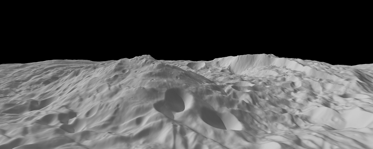
PASADENA, Calif. — A new image from NASA’s Dawn spacecraft shows a mountain three times as high as Mt. Everest, amidst the topography in the south polar region of the giant asteroid Vesta.
The peak of Vesta’s south pole mountain, seen in the center of the image, rises about 13 miles (22 kilometers) above the average height of the surrounding terrain
Another impressive structure is a large scarp, a cliff with a steep slope, on the right side of this image. The scarp bounds part of the south polar depression, and the Dawn team’s scientists believe features around its base are probably the result of landslides.
This image was created from a shape model of Vesta, and shows an oblique perspective view of the topography of the south polar region. The image resolution is about 300 meters per pixel, and the vertical scale is 1.5 times that of the horizontal scale.
Alice Says
NASA’s caption is pretty clear, most important is to note that THIS IS A CGI IMAGE, and it is vertically exaggerated 1.5 times. This mountain is measured from the average height of the ground around it.
MESSENGER

Lava Flow on Mercury Credit: NASA/Johns Hopkins University Applied Physics Laboratory/Carnegie Institution of Washington
NASA Caption
Date acquired: April 20-22, 2011
Release Date: October 17, 2011
Instrument: Wide Angle Camera (WAC) of the Mercury Dual Imaging System (MDIS)
Of Interest: This mosaic shows the geological contact between a lava flow front, which advanced from the west (left) and the pre-existing terrain that it covered. The lava flowed into and almost completely filled a medium-sized crater in the center of the scene. Other amazing lava flow features were shown in recent Gallery releases.
Alice Says
NASA’s caption says you can see an ancient, solidified lava flow here, and you can see how it covers the land behind it. The front is just like the crest of a water wave – only this was a wave in rock and it froze in place as the lava solidified.
It is a little hard to tell which is the lava flow front here – the line that runs vertically through the image, or the one that runs horizontally. They cross exactly in the middle of the image. NASA’s caption is talking about the vertical line. You can see the crater they’re talking about – you can only see the top right-hand quarter of the rim of the crater, just above where the two lines cross.
Want More?
Worlds of Stone at Pacific Science Center
![]()
~ A l i c e !
 Worlds of Stone, Worlds Unknown: NASA Investigates Mercury and the Asteroid Belt
We opened a new show in the Willard Smith Planetarium at Pacific Science Center. It’s all about NASA’s current missions in the inner solar system: MESSENGER to Mercury and Dawn to Vesta and Ceres.
As part of that show we’re updating the images we show from MESSENGER and Dawn on a weekly basis. I’ll try to show them to you the week after we use the in the planetarium.
Dawn
NASA Caption
Released October 12, 2011
PASADENA, Calif. — This detail of a Dawn FC (framing camera) image shows a fresh scarp rimmed crater with many boulders on the crater floor. These boulders have diameters of 100-200m, which is roughly the size of many asteroids! Also evident in this image are linear mass movement features, which originate from the rim of the crater (bottom of image) and are due to material slumping towards the center of the crater. There are also many smaller, and presumably younger, impact craters on the walls of this crater.
NASA’s Dawn spacecraft obtained this image with its framing camera on September 20th 2011.
Alice Says
Let me unpack what NASA said for you:
- “Fresh scarp rimmed crater “ – This crater is new, and it has a sharp edge, like a cliff (a scarp).
- “Boulders on the crater floor. These boulders have diameters of 100-200m,” – That’s those tiny black dots in the middle there.
- “Linear mass movement features” – Dirt moved. It moved in a straight line. The lines you see that go from the edge of the crater in towards the middle are these “linear features.” And technically I shouldn’t call it dirt. Regolith is better, but dirt gives you the right idea.
- “Due to material slumping towards the center of the crater.” – slumping is like sliding. Imagine yourself sitting against a wall. You sit straight at first and then get tired so you scootch down a little, and maybe lean over on your elbow. Slumping is dirt doing the same thing, it’s just … slumped. It’s different that sliding because when you slide you end up all in a completely different place. Slumping you just compact in place, maybe spreading out a little at the bottom.
- “Presumably younger” – when one crater is on top of another you can assume the crater on top is younger.
The boulders (dots) are my favorite part of this image.
MESSENGER

Mercury in Limb-O Credit: NASA/Johns Hopkins University Applied Physics Laboratory/Carnegie Institution of Washington
NASA Caption
Date acquired: September 19, 2011
Instrument: Wide Angle Camera (WAC) of the Mercury Dual Imaging System (MDIS)
Of Interest: This image provides us with a beautiful view of a portion of Mercury’s southern hemisphere. The bright rayed crater near the limb is Debussy.. Also visible, near the center of the image, is Matabei, a small crater distinguishable by its unique dark rays.
These limb images provide information about Mercury’s shape.
Alice Says
I love bright craters – they’re bright because they’re new, not because their composition is different. So rocks are made of minerals, and minerals are usually crystals: they have a lattice of atoms very perfectly aligned. If you just leave a crystal out on a planet it gets scratched up, banged around and the surface gets marred or weathered. If you crack that crystal open, it cracks (cleaves) along those perfect lattice boundaries, between atoms, exposing a new surface. This surface is perfectly flat –flat at the molecular level!! – and therefore reflective like a mirror. This is a cleavage plane. When you smack a meteorite into a planet, you kick up a bunch of rocks and minerals, cracking them all open along those cleavage planes. These fall back down to the planet, reflective, pretty, and unmarred – which looks from space like a bright white crater and rays.
Want More?
Worlds of Stone at Pacific Science Center
![]()
~ A l i c e !


